


Cactus to Clouds to Cactus
- Rhianna Walzer
- Mar 6
- 8 min read
Updated: May 1
Climbing 11,400' From the Desert Floor to the Clouds and Back
Quick Stats
December 8, 2024
5:00 am start time
Skyline Route: Cactus to Clouds to Cactus
29.61 miles
11,400 ft of elevation gain
11 hours 45 minutes
GPX File
Trip Overview
Cactus to Clouds (C2C) is a very famous hike, climbing the full height of San Jacinto (10,834’) from the desert floor in Palm Springs. A quick google search of “Cactus to Clouds” results in daunting titles like “America’s Hardest Hike”, “The Toughest Hike in the USA”, “Hardest Day Hike in the US”. This hike however ends at the Palm Springs Aerial Tramway, cutting the day to 19 miles. The tram glides you back down to the desert, forgiving your legs of a grueling 10 mile descent back to where you started at the Palm Springs Art Museum.
In December 2023 I did C2C solo unsupported. It was my first taste of self-sufficient adventure. I was scared shitless the night before. Fear of mountain lions, strangers, snakes, and conditions (mostly mountain lions) kept me awake that night. I was nervous and anxious yet prepared and competent. Ambition got me out of bed at 4:00 am and persistence tied my trail shoes and put on my already packed pack. I went anyways.
I wrapped up C2C in about 7 hours and climbed onto the tram. I was caked in dirt and smelled horrible. Next to me, people were dressed up, riding back to their parked cars after lunch at the tramway. Standing on the tram, meditating on my adventure, I knew I had to come back for the full thing - Cactus to Clouds to Cactus (C3).
That day ignited something deep within me. C2C was my first solo adventure, and that alone was empowering. But beyond that, I had never felt more terrified or anxious than I did the night before. Like anything, exploring the mountains solo is a skill — one that gets easier with practice. And now, it is easier. I still feel fear, but nothing like what I experienced before C2C. I realized that the Do It Scared mindset is addictive. I want to prove to myself, again and again, that I can accomplish challenging feats in the mountains.
Trip Report
I might thrive on solo adventures, but there’s something special about tackling a challenge with a good friend. When my go-to trail partner reached out jonesing for a winter objective, I knew exactly what to offer — the magic of San Jacinto. We locked in C3 for an early December mission.
This trip was a trail running and rock climbing extravaganza. We stayed at an Airbnb in Joshua Tree to climb a little and run a lot. Joshua Tree is only 50 minutes from the C3 trailhead, and if you are traveling to the area for a longer stay, I recommend staying here. Joshua Tree is quiet, eclectic, and the National Park is a must-do day trip.


After a long day of climbing in the park, we had pizza for dinner from Sky High Pie, the best sourdough pizza ever, and laid out our gear (see gear list) for the big adventure in the morning. We set alarms for 4:00 am and woke to quickly brew coffee, cook breakfast, pack the car, and drive the 50 minutes to the trailhead listening to hype up songs. It was another perfect December forecast for San Jacinto. Skyline was forecasted to have a high of 70 and the summit of San Jacinto 40 and sunny.
The Skyline Route begins at the back of the Palm Springs Art Museum. There is a plentiful lot for the trailhead and parking shouldn’t be an issue as most people start the trail before sunrise (see parking note). We pulled into the trailhead, and to my surprise, there was one other car and a headlamp already moving up the switchbacks. Last year, for C2C, no cars joined me at the trailhead and I was the only soul on that section of the trail. Tyler and I finalized our pack organization, extended trekking poles, tied up shoes, started watches, and passed the trailhead sign.
The trail is steep from the start and does not let up until you reach the Ranger Station at mile 10. Initially, the trail is difficult to follow. The first few miles might feel frustrating navigationally. A GPX file is crucial, especially if you are doing this section in the dark. There are perpendicular trails along with tracks from people moving off-trail. Luckily, there are white spray paint markers for the Skyline Route, trying to help, but do not rely solely on spotting these. Their frequency is too inconsistent.
Tyler and I quickly caught up to the floating headlamp and gave a happy trails greeting. He was a reporter doing a piece on the famous hike. He whipped out a fancy camera and asked: “Mind if I snap a few photos?” to which we cheerfully agreed, I felt like a professional athlete. Come to think of it, nothing ever came of those photos and we never saw the published article. Maybe we were too quick to let a stranger in the darkness take photos of us in the middle of nowhere as he ran ahead of us and then followed us on our heels on a dirt trail headed to the middle of nowhere. But, now, safe and sound from my couch, I can write about it as a funny memory and a part of the day I won’t forget.
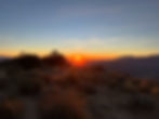
In the dark, the Palm Springs city lights flicker. As we climbed, they looked less and less like buildings, street lights, and cars, and turned into glowing geometric blobs. Quickly, the blackness of the skyline at our backs started to lift. The sky turned pink, then orange, then gave way to the sun which lit up the wilderness in front of us. Sunrise was perfect, the trail completely transformed. We no longer followed a small circle of light. The sun gave us a new energy.


2 hours and 5 miles into our day we breaked. I refilled my 2 front 500mL soft flasks from the water reservoir I had in the back of my pack (see water note) and grabbed out a new set of calories, about 300-400 high carb calories for the next 2 hours (see nutrition note). The refuel routine: take out front soft flasks, pour BPN G1M Sport powder into each flask, refill water, and take out a new set of calories. I do this every two hours. After the refuel routine, we were back to more of the same, uphill climbing.


Miles 7 to 9 are the toughest C3. Grubbs Notch is an unrelenting steep and loose section. Trail navigation is challenging here and it was helpful to check in with the GPX file every so often. We moved over falls trees, dodged huge Coulter pinecones, and tripped on loose scree. Once over the notch, the trail let up and we had a short mile to the Ranger Station.
The Ranger Station is like a race aid station - other humans are mulling around, high on being outside. It’s a fantastic break with restrooms, water, and a picnic table to grab a snack. Here, you fill out a free permit (see permit note), getting the paperwork all sweaty. This stop was blissful after those grueling 10 miles.
Getting to the summit of San Jacinto is a blast and goes very fast. The trail grade lightens, there are more friendly faces, and the views are no longer of Palm Springs but of expansive wilderness. Mile 12, Wellman’s Divide, is a gorgeous viewpoint. We took in the views along with deep breath before we continued upward. We felt the elevation on our lungs as we climbed closer and closer to the top of San Jacinto. We reached the summit in 7 hours. Tyler and I shared a pop tart, refilled water, snapped a few photos of the high point sign, booped the survey marker, and turned around to travel back the way we came.


My lungs were happy to not be working so hard at elevation but my quads were not happy to be stabilizing a brisk downhill run. Little did they know they had 5 more hours to grind out. Retracing steps on a vertical trail always feels like a new trail itself. Views, speed, and energy change. I felt like a train chugging along on our way back home. 3 miles to Wellman Divide, 2 more to the Ranger Station, final water refill, 2 miles through Grubbs Notch, 8 more to the trailhead. All while said train was in need of maintenance. My toes sore from jamming into my shoes, stomach uncomfortable from bracing as we ran downhill, and hip flexors fatigued from pushing uphill for 7 hours.
Though uncomfortable, I was filled with gratitude. Here I am with one of my best friends, in a beautiful place, completing a bucket list trail. Here I am, a year later, and C3 is just another day on the trails. 11,355 feet of vertical isn’t daunting, it’s invigorating. 30 miles isn’t crazy, it’s a great workout. This was a different empowering feeling than the one I had after C2C.
C2C fired up the woman in me. C3 fired up the athlete in me.
That’s why these big objectives are so fulfilling. The trails awaken everything about me. I find purpose, vision, and energy. I learn far more about myself than I could in basic training. Each time it’s different and the only way to find out is to adventure.
Tips & Tricks!
Permit
There is a free self-service permit at the Ranger Station at the top of the tramway. Fill out your permit to summit San Jacinto here. Half of the permit is left in a box, the other half travels with you until you return to the station. Be sure to return your permit on your way back through the Ranger Station.
Parking
The Palm Springs Art Museum has plentiful parking at the Cactus to Clouds trailhead. For C3, you can park here for free with no time restriction.
Water
There is no water in the first 10 miles and then in reverse for the last 10 miles. There is a water spigot at the Ranger Station at approximately mile 10 out and mile 19 back. There are natural water opportunities between the Ranger Station and San Jacinto summit from the Long Valley Creek.
For my water plan, I packed 2.5L of water to start - 1L in my front soft flasks and 1.5L in a Platypus water bottle stored in the back of my pack. This would be enough to make it to the Ranger Station. From the Ranger Station, I brought 1.5L of water for the summit and back. Finally, from the second Ranger Station stop, I packed 2L of water to finish the day. This more than covered 500mL per hour.
Nutrition
I aimed to consume 150-200 calories per hour. I packed 2,400 calories worth of snacks and BPN G1M Sport endurance fuel. For BPN G1M Sport, I am just shy of 1 scoop per 500mL of water (For me, a full scoop per 500mL of water is too powerful of a flavor). Predicting around 12 hours, I packed roughly 12 scoops of G1M Sport.
Gear List
Kit
Garmin Fenix 7S Pro Watch
Salmon Active Skin 8 Vest
Black Diamond Distance Carbon Z Poles
Black Diamond Deploy 325 Headlamp
HH LIFA® ACTIVE Solen Hoodie
REI Swiftland Running T-Shirt
Patagonia Multi-Trails Shorts
Darn Tough Micro Crew Socks
Hoka Mafate Trail Runners
Running hat
Sunglasses
Emergency Pouch
Garmin inReach Mini 2
First Aid Kit
Tylenol
Extra Sodium (LMNT or Salt Tabs)
Sawyer Squeeze Water Filter
Aquatabs
Sunscreen
Aquaphor
Water
2 x 500mL Soft Flasks
2L Platypus Water Bottle
Nutrition
BPN G1M Sport (10 scoops)
SaltStick Chews
Kate's Real Food Bars
GoGo Squeez
Chomp Beef Jerky
Poptart
Dates

Not sure where to start on nutrition? Check out The RunnerBox®! Packed with go-to favorites picked by people who’ve been there, done that, and know what really works. Use code GETSTOKEDGIRLS to get your first box free when you purchase an annual subscription — get set for a year of fueling!